UN
9 Victory Way
£ 300,000
Description
We don't have a Description for this property.
- Bedrooms
- 3
- Bathrooms
- 0


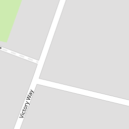

Leaflet © OpenStreetMap contributors
The heatmap indicates the level of crime in the area. The color of the heatmap indicates the crime severity and recency.
Metrics Year-on-Year
- Average area value
- 450,015.00 £Increased by 11.82 %
- Average area rental value
- 1,360.00 £/moDecreased by 3.41 %
- Est rental Yield
- 3.63 %Decreased by 13.57 %
- Crime Rate
- 7.00 %Unchanged by 0.00 %
from 402,439.00 £
from 1,408.00 £/mo
from 4.20 %
from 7.00 %
Nearby Schools
| Name | Type | Ofsted | Distance |
|---|---|---|---|
| Crownfield Junior School | Community School | Good | 0.23 KM |
| Crownfield Infant School | Community School | Good | 0.23 KM |
| St Patrick'S Catholic Primary School | Voluntary Aided School | Good | 0.41 KM |
| Collier Row Children'S Centre | Children's Centre | 1.18 KM | |
| Clockhouse Primary School | Community School | Good | 1.27 KM |
Images
Nearby Streets
| Name | Average Price | Average Sqft | Distance |
|---|---|---|---|
| Hamlet Close | £ 0 | 0 | 0.00 KM |
| Pitcairn Close | £ 0 | 0 | 0.00 KM |
| Westwode Close | £ 0 | 0 | 0.00 KM |
| Adams Close | £ 550,000 | 0 | 0.00 KM |
| Lynwood Close | £ 0 | 0 | 0.00 KM |
Nearby Transport
| Name | NLC | TLC | Distance |
|---|---|---|---|
| Romford | 6886 | RMF | 3.48 KM |
| Chadwell Heath | 6874 | CTH | 4.20 KM |
| Gidea Park | 6877 | GDP | 5.49 KM |
| Goodmayes | 6878 | GMY | 6.00 KM |
| Seven Kings | 6893 | SVK | 7.42 KM |
Nearby Listings
| Address | Price | Type | Score | Distance |
|---|---|---|---|---|
| Three Bedroom Terraced house RM7 | £ 399,950 | BUY | Unknown | 0.02 KM |
| Valiant Close, Romford, RM7 | £ 600,000 | BUY | Unknown | 0.07 KM |
| White Hart Lane, Collier Row, RM7 | £ 375,000 | BUY | 6 / 10 | 0.13 KM |
| 76 White Hart Lane, Romford, Essex, RM7 8JB | £ 270,000 | BUY | 5 / 10 | 0.14 KM |
| Peartree Gardens, Romford | £ 450,000 | BUY | 6 / 10 | 0.14 KM |
Nearby Properties
| Address | Price | Distance |
|---|---|---|
| 29 Victory Way | £ 184,500 | 0.00 KM |
| 18 Victory Way | £ 357,000 | 0.00 KM |
| 24 Victory Way | £ 335,000 | 0.00 KM |
| 23 Victory Way | £ 167,500 | 0.00 KM |
| 4 Victory Way | £ 250,000 | 0.00 KM |